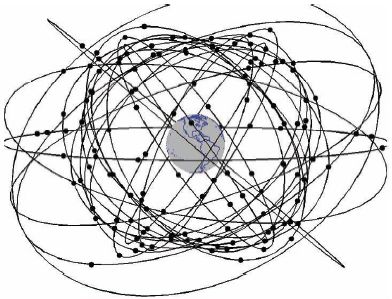
GNSS
Global navigation satellites systems are nowadays so interconnected with our lives that we don’t even know which technology is hidden behind the screens of ours mobile phones. Satellite systems such as GPS, GLONASS, Galileo or COMPASS and the local satellite navigation systems BEIDOU (Chinese "regional" satellite system) and IRNSS (Indian "regional" satellite system) allow or will allow precise navigation around the world.
But how these system succeed in the field of air navigation? Will they replace current air navigation systems?
It is certain that together with powerful on-board navigation devices, they will surely form the backbone for global navigation air navigation, but they probably won’t be the hegemon of air navigation because of reasons described below.
Advantages and disadvantages
Advantages
- Worldwide expansion
- Accuracy
- Availability
- Range
Disadvantages
- National systems (owned by one or more countries)
- Integrity
- Accuracy in height measurement
The benefits that are described here clearly show why GNSS is expanded globally for navigation on the ground. It is important to underline the word ground because the described disadvantages are not fundamental to ground navigation – in case of signal failure, it will usually not cause serious problems. However for air navigation, the disadvantages are so critical and crucial that they do not allow global navigation satellite systems to be the one and only system for air navigation.
The underscored disadvantage is that even GNSS signals are declared for global use and free for all, they are managed (except the European Galileo system) by individual states or even by their armies. The question is what would happen in a possible war conflict - whether the civilian sector can be 100% sure that the declared signal will really be provided
An example of where the army was given priority over the civilian sector may be a NOTAM release for part of the US airspace where GPS accuracy has been reduced due to naval exercise. There have also been issued warnings for Embraer Phenom 500 aircraft that are dependent on GPS to completely avoid this area for safety reasons.
There is also clear evidence that Americans in the battlefield deliberately reduce the accuracy of the GPS signal so that the enemy can’t use the GPS. We shouldn’t make a false illusion that any GNSS would be over army purposes.
If we overcome these military pitfalls, there is one more thing that is a far greater problem - integrity.
Integrity
Satellite navigation systems alone are not capable of providing the required integrity. This is the ability to pass on information about the proper function of satellites and their signals. For example, if information from one satellite is lost and precision falls below a given minimum, we need to pass this information onboard the aircraft so that the onboard navigation systems stop using this signal.
Additional/expansion equipment must be deployed to ensure integrity. Primarily, the GNSS signal is monitored by a network of ground control stations. But it is necessary to have such a network widespread worldwide. An example of a properly expanded network of control stations is GPS, which is currently the backbone of the entire GNSS. An opposite example may be Russian GLONASS, which has only a small number of control stations outside of its territory thanks to Russian foreign policy and is able to check all satellites only once every 12 hours!
In order not to be dependent only on the GNSS control network, augmentation systems are introduced into GNSS. Augmentation systems ensure integrity and also give corrections to whole system. Firstly they internally examine the quality of the GNSS signal and whether the data are valid. We divide them to:
ABAS
ABAS - aircraft based augmentation system - cooperation with other systems on board aircraft (IRNS, altimeter, etc.)
- RAIM - On-board device monitors the integrity of GNSS data from 5-6 satellites directly on. If a signal error is evaluated the on-board device will alert or eliminate the wrong signal from
- AAIM - On-board GNSS equipment is extended with additional independent navigation devices on board an aircraft such as a barometric altimeter, INS or "classic" DME, VOR, ILS.
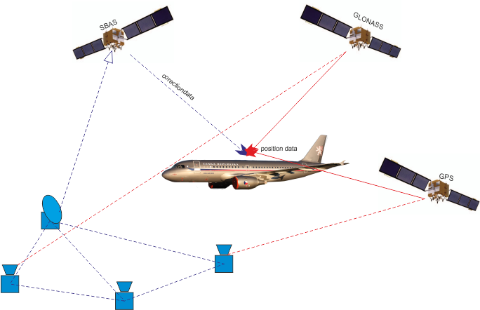
SBAS
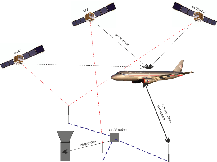
SBAS - (satellite based augmentation system) is an extension/augmentation system based on a ground correction station network and geostationary satellites. These stations monitor the GNSS signal and transmit the signal information to the control stations over the telecommunication lines. After the signal evaluation, the control station sends correction data to geostationary satellites and via them to users.
It is the most costly but most efficient way of augmentation systems. Currently, there are several concepts that are at different stages of development or research and are mostly regional:
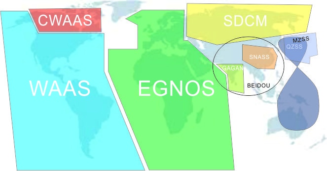
- WAAS – USA area
- CWAAS – Canada area
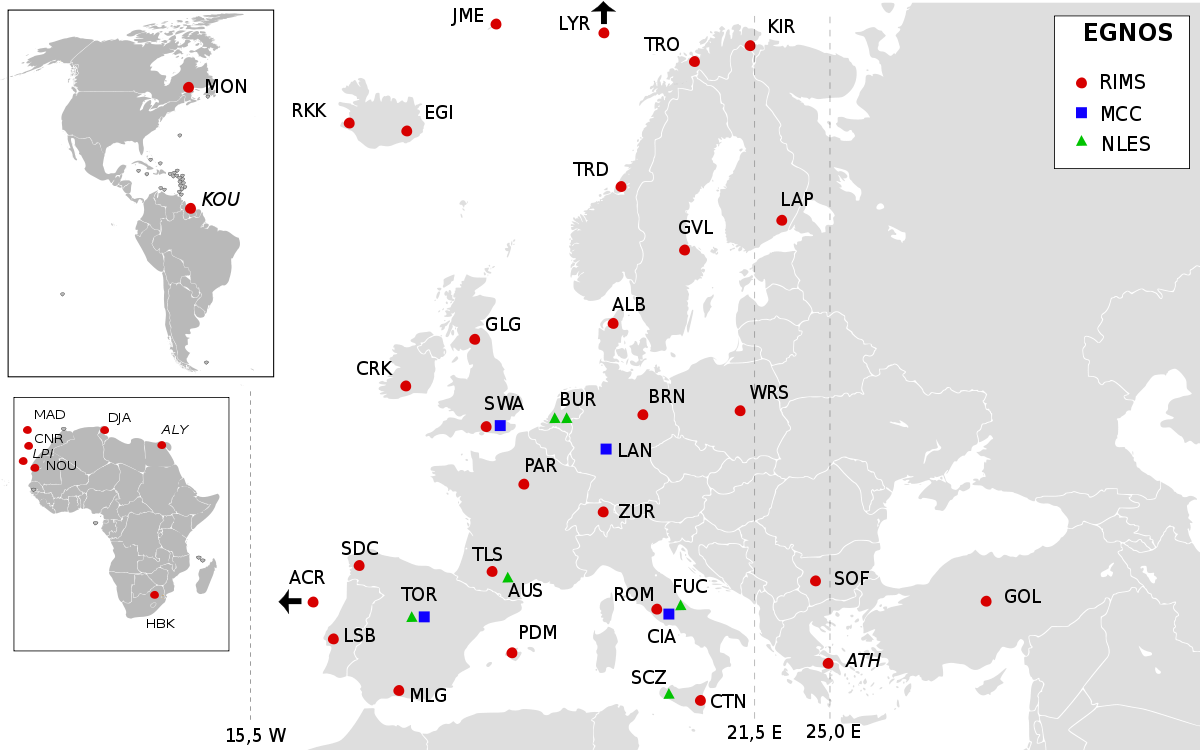
- EGNOS – EU area
- MSAS – Japan area
- QZSS – Japan area – It is the most costly but most efficient way of augmentation systems. Currently, there are several concepts that are at different stages of development or research and are mostly regional:
- GAGAN – India area
- SNAS – China area
- SDCM – Russsia area
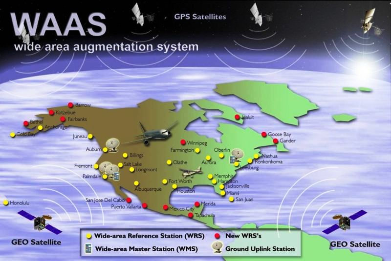
SBAS systems use standard geostationary telecommunication satellites that broadcast in the L band, especially from Inmarsat (WAAS and EGNOS). Others use their own geostationary satellites.
GBAS
GBAS - ground based augmentation system – use ground network of correctional stations to enhance GNSS precision approach landing system – SCAT I (CAT I). The GBAS consists of 3-4 reference stations that evaluate the integrity and accuracy of the GNSS data and the datalink that sends data on board the aircraft.
GRAS
GRAS - extension of the GBAS augmentation system. It is a GBAS system that is applied to larger territories and has multiple levels of service provided for different phases of flight. GRAS is divided into:
- GRAS A - GRAS, which is divided into territorial "cells" that are not interconnected, but the best signal is evaluated on-board.
- GRAS B - Territorial cells are interconnected in the network. Signal evaluation and correction are applied to the entire network.